- Hochschule Trier
- Campus wählen
- Quicklinks
-
- English

Background:
The Earth's cry for help echoes through the retreating glaciers and the shifting habitats of alpine species, offering visual testimony to the profound impacts of climate change. The overarching aim of this research is to transcend traditional scientific communication barriers and engage a broader audience in the discourse on climate change. Through captivating visualizations, we endeavor to make the abstract concept of climate change tangible and relatable. The intricate interplay between glacier recessions and elevational range shifts serves as a metaphor for the interconnectedness of Earth's systems and the far-reaching consequences of anthropogenic climate change.
Glacier Recession:
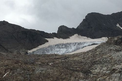
These days, glaciers are experiencing unprecedented rates of recession due to rising global temperatures. Utilizing space-time visualization tools, we present a visual narrative of glacier retreats over the past decades monitored at the Laaser Ferner (ID RGI60-11.01473) and the glaciers of the Ortler group in Northern Italy by using different sources. This dynamic portrayal of the accelerating loss of ice mass serves as a poignant reminder of the urgent need for climate action. Recent analysis of the extension of the glacier using Earth Observation data (Landsat, Sentinel) between the years 1986 – 2023 and data from the World Glacier Monitoring Service (WGMS) are stating a dramatically decline of the Laaser Ferner area of 44%.
Dance of Survival:
Simultaneously, based on data derived from a metastudy, we turn our attention to alpine ecosystems, where species are engaging in a delicate dance of survival, especially at the high altitudes level. As temperatures rise, alpine plants and animals are compelled to ascend to higher elevations in search of cooler climates. The elevational range shifts of these species (e.g. Lagopus muta helvetica) measured in different studies and captured through space-time visualizations, tell a tale of adaptation in the face of environmental conditions change.
Visualization Techniques
Having 4D-Geospatial Information, we are using and experimenting with the latest technology in QGIS, GoogleEarth Studio, GoogleEarth Engine and Unity to foster climate change awareness. Some examples you will find below.
Konsortium: Umwelt-Campus Birkenfeld, FB Umweltplanung / Umwelttechnik, Prof. Dr. Peter Fischer-Stabel
Laufzeit: Mai 2024 – Juni 2026

Address
Institute for Software Systems in Business, Environment and Administration
Campusallee, Buidling 9925
55768 Hoppstädten-Weiersbach
Sie verlassen die offizielle Website der Hochschule Trier